Friday’s Itinerary
Alright, I tried but I just can’t get us to Greenridge and back, including picking up the DAMN tag and without getting on the highway, in one reasonable day. Additionally, I know some indicated they can only join in for a portion of the ride so in an attempt to facilitate that, the plan is this (with a pretty map included for your enjoyment):
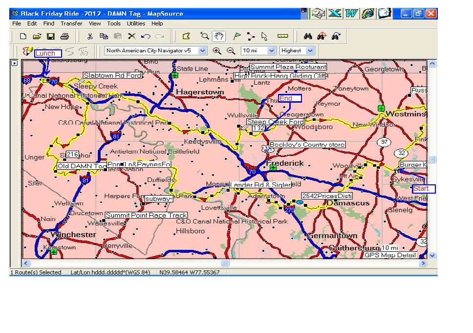
1. We will roll wheels out of Burger King in Eldersburg at 8:30 am. Have your tank full, your belly full and your bladder empty!
2. We will make our way South on some nice little back roads with the occasional bits of dirt thrown in where ever they can be found.
3. Let’s hope the day warms up quickly as we will then turn West and hit a few little water crossings, one on Price’s Distillery and one on Sigler. Please no Golden Snorkel Awards on this trip!!
4. Popping out at Harpers Ferry, we will shadow the Potomac up-stream all the way to Shepherdstown and finally pop-over the river using the nice bridge that the State has graciously supplied.
5. We will then grab the current DAMN tag last planted by Bucho on Pond Lane. Then, keeping with the water theme, we will check out the previous DAMN tag planted by Ken and Bonehead; in the middle of the very deep-ass Back River Ford (this crossing will be “optional”)…
6. We will then turn North on some more little Roads-Less-Traveled. There is one dotted line in the GPS (i.e. a dirt road) that we will try to find but I won’t be surprised if it is gated. It appears to run along the ridge of a mountain and could be very cool (or a total waste of time…) but the name of the road is “WV DNR road 826” thus access is uncertain (even though the gps treats it as a routable road). Does anyone happen to know if hunting season is “in” on Friday in West Virginia as I think this could also be a concern with this road?
7. Eventually we will cross back over the Potomac in Hancock where we will stop for Lunch. Wingfixer, this is your hood, there are all kinds of places to eat in Hancock, what do you recommend?
8. With bellies again full we will seek out Slab Town Rd Ford. I have never personally been through this one so you can expect at least half a dozen U-turns and dumb looks as the GPS recalculates as we try to find our destination.
9. This will be followed up with making our way back East on some secondary roads until we get closer in to the Frederick area where we will have our Grand Finale…
10.…. a climb up the always fun Hawbottom road followed by dropping down to our last little water crossing at Steep Creek Ford. When we emerge out onto Rt 15, the official ride will be over and who ever is left can split to where ever they are from….
From the official start in Eldersburg to the end at Steep Creek Ford (not including bonus U-turns) will be just over 200 miles.
If anybody want a copy of the GPS file, e-mail me: J-shaffer at comcast.net
Looking forward to seeing everyone!
Jay